Joseph Mallord William Turner Notes of Sights between Koblenz and Trier 1824
Image 1 of 2
Joseph Mallord William Turner,
Notes of Sights between Koblenz and Trier
1824
Joseph Mallord William Turner 1775–1851
Folio 6 Verso:
Notes of Sights between Koblenz and Trier 1824
D19563
Turner Bequest CCXVI 6 a
Turner Bequest CCXVI 6 a
Pencil and pen and red ink on white wove paper, 118 x 78 mm
Inscribed in pencil and pen and red ink by Turner (see main catalogue entry)
Inscribed in pencil and pen and red ink by Turner (see main catalogue entry)
Accepted by the nation as part of the Turner Bequest 1856
References
1909
A.J. Finberg, A Complete Inventory of the Drawings of the Turner Bequest, London 1909, vol.II, p.667, as ‘List of towns on “Right Bank” of Meuse’.
1977
Timothy Clifford, Vues pittoresques de Luxembourg: Dessins et aquarelles par J.M.W. Turner 1775–1851, Luxemburg 1977, p.12.
1978
Agnes von der Borch, Studien zu Joseph Mallord William Turners Rheinreisen (1817–1844) (Ph.D. thesis, Rheinischen Friedrich-Wilhelms-Universität, Bonn 1972), Bonn 1978, pp.61–2.
1980
Agnes von der Borch and Gerhard Bott, J.M. William Turner: Köln und der Rhein: Aquarelle Zeichnungen Skizzenbücher Stiche, exhibition catalogue, Wallraf-Richartz-Museum, Cologne 1980, p.86.
1991
Cecilia Powell, Turner’s Rivers of Europe: The Rhine, Meuse and Mosel, exhibition catalogue, Tate Gallery, London 1991, pp.37 note 1 [p.60], 122 no.36.
1995
Cecilia Powell, Turner in Germany, exhibition catalogue, Tate Gallery, London 1995, p.30 note 4 [p.77].
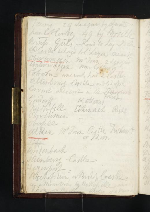
This is the first of four pages of notes Turner extracted and copied from the ‘Third Excursion’ of Alois Wilhelm Schreiber’s The Traveller’s Guide down the Rhine (see also Tate D19564–D19566; Turner Bequest CCXVI 7–8). The manuscript notes on these pages list the names of towns and the distances between them, sites of historical interest, antiquities, picture collections, inns and travel information for the journey between ‘Coblentz to Trêves’ when travelling ‘the course of the Moselle’.1 Turner’s use of Schreiber’s guidebook, published in English in 1818, is discussed in the general Introduction to this tour.
The artist’s notes are transcribed thus:
‘Treves 24 Leagues by Land
from Coblentz 49 by Moselle
Wwiss Guls Road to Ley Rock
Old Castle belongs to Cs Leyen near it
Oberwinggen Mt Town 2 Leagues
Unterwinggen from Coblentz
Cobern ancient had 2 Castles
Altenbourg Castle and Chapel
Convent ancient in the Stoperwald Forest
Gondorff Kattenes
Niederfell Echenach Right
Oberleimen
Oberfell
Alken Mt Town Castle Turant or Thorn
Liff
Brodenbach
Steinburg Castle
Hezenport
Bischofstein or Bishop Castle
on a Mountain by the Moselle and
Rhon on the other Chapel of 3 Maries’2
Turner’s notes correspond exactly to Schreiber’s text. The artist’s ‘Treves 24 Leagues by Land’ is a shortened version of the German author’s opening line: ‘Although Trêves is only twenty-four leagues from Coblentz, if the traveller wishes to follow the course of the Moselle from one town to another, he must pass over a space of forty-nine leagues’.3 The excursion, for Schreiber, is far superior over water than land as ‘the banks of the Moselle abound with fine views, and each village or group of mountains forms itself a delightful landscape’.4
The itinerary Schreiber proposes begins with the a visit to the villages of Weiss and Güls, ‘where large quantities of cherries are gathered’ for export to Cologne.5 ‘After having passed these two places’, the traveller is met by a chain of mountains and a road leading to the village of Ley, from ‘whence the Counts of Leyen derive their origin’.6 Then, one proceeds to the market towns of Oberwinnigen and Unterwinnigen (listed by Turner as ‘Oberwinggen’ and ‘Unterwinngen’). From there, the road leads to Cobern, a ‘place made a considerable figure in the history of the eighth century’ for its ‘two castles called the lower and upper castle, or Altenbourg, of which some ruins still exist’.7 From Schreiber’s recommendation, Turner makes note of the chapel at Cobern: ‘a remarkable specimen of ancient German architecture... supposed to have been erected in the time of the Crusades’, as well as the neighbouring Stöperwald forest with its ‘ancient convent of Marienroth’.8
After passing ‘the pretty villages of ‘Gondorf, Niederfell, Oberliemen, ad Oberfell’ situated on the banks of the Moselle, the traveller comes to Alken, ‘where may be seen the majestic ruins of an old castle, commonly called Turant’.9 Schreiber writes that the castle’s ‘original name was Thoron, or Thorn, which it derived from the form of a mountain where it was constructed by the Pfalzgrave [Palatine Count] Henry, as a defence against his brother Otto’.10 From Alken, ‘a number of beautiful villages and market-towns’ present themselves: those of Löf, Brodenbach, Steinberg and its castle, and Hazenport.11 Soon after, the majestic Burg Bischofstein comes into view, situated ‘on the summit of a very lofty mountain, at the foot of which runs the Moselle on one side, and the torrent of the Rhon on the other’.12 Constructed by the Bishop of Trèves in the ‘sixth century’, it was once ‘a very extensive’ stronghold, ‘having as many as thirty towers’ though ‘only one tower and the chapel of the three Marys now remain’.13
Alice Rylance-Watson
February 2014
Alois Wilhelm Schreiber, The travellers’ guide down the Rhine: exhibiting the course of that river from Schaffhausen to Holland, and describing the Moselle from Coblentz to Treves with an account of the cities, towns, villages, prospects, etc, London 1825, p.174.
How to cite
Alice Rylance-Watson, ‘Notes of Sights between Koblenz and Trier 1824 by Joseph Mallord William Turner’, catalogue entry, February 2014, in David Blayney Brown (ed.), J.M.W. Turner: Sketchbooks, Drawings and Watercolours, Tate Research Publication, April 2015, https://www


