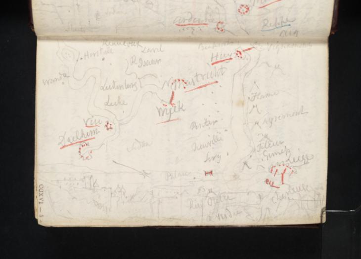
Joseph Mallord William Turner Sketch Maps of the Meuse between Huy and Liège, and Liège and Maastricht; Sedan 1824
Image 1 of 2
Joseph Mallord William Turner,
Sketch Maps of the Meuse between Huy and Liège, and Liège and Maastricht; Sedan
1824
Joseph Mallord William Turner 1775–1851
Folio 5 Recto:
Sketch Maps of the Meuse between Huy and Liège, and Liège and Maastricht; Sedan 1824
D19560
Turner Bequest CCXVI 5
Turner Bequest CCXVI 5
Pencil and pen and red ink on white wove paper, 78 x 118 mm
Inscribed in pencil and pen and red ink by Turner (see main catalogue entry)
Inscribed in blue ink by Ruskin ‘5’ top right
Stamped in black ‘CCXVI–5’ bottom right
Inscribed in pencil and pen and red ink by Turner (see main catalogue entry)
Inscribed in blue ink by Ruskin ‘5’ top right
Stamped in black ‘CCXVI–5’ bottom right
Accepted by the nation as part of the Turner Bequest 1856
References
1909
A.J. Finberg, A Complete Inventory of the Drawings of the Turner Bequest, London 1909, vol.II, p.667, as ‘View of “Sedan”; also sketch plans of River Meuse, between Maastricht and Liege, and Liege and Huy’.
1978
Agnes von der Borch, Studien zu Joseph Mallord William Turners Rheinreisen (1817–1844) (Ph.D. thesis, Rheinischen Friedrich-Wilhelms-Universität, Bonn 1972), Bonn 1978, pp.61–2.
1991
Cecilia Powell, Turner’s Rivers of Europe: The Rhine, Meuse and Mosel, exhibition catalogue, Tate Gallery, London 1991, p.37 fig.24 and note 1 [p.60].
1995
Cecilia Powell, Turner in Germany, exhibition catalogue, Tate Gallery, London 1995, p.30 note 4 [p.77].
This is a continuation of the sketch map on the folio opposite (Tate D19559; Turner Bequest CCXVI 4a), and shows the course of the River Meuse between the Belgian cities of Huy and Liège and between Liège and Maastricht in the south-east of the Netherlands.
Turner’s map of the Belgian stretch of the Meuse begins with ‘Beaufort’, a reference to the ruined castle keep of Beaufort which overlooks the valley at Lovegnée from atop a lofty spur (see Tate D29643; Turner Bequest CCXCVI 24). Erected by the lords of the same name in the twelfth century, the site is also home to the remains of an oratory where the local community once celebrated mass.1 ‘Huy’ is shown beneath Beaufort, near Vinalmont (‘Vign[...]t’), and followed by: ‘Flame’ (Flémalle) and ‘Agremont’, i.e. the Château Aigremont, an ancient stronghold of the La Marck family (see Tate D19558; Turner Bequest CCXVI 4). By the time of Turner’s visit, Aigremont was the home of the descendents of Archedeacon Mattias Clercx, who had purchased the fortress in 1715 and transformed it into a palace with lavish Baroque interiors and gardens laid in the French seventeenth-century style.2 From Aigremont, Turner notes ‘Neuville’ (Neuville-en-Condroz), ‘Tileur’ (Tilleur), ‘Gemeps’ (Jemeppe), ‘?Serg’ (Seraing), and finally, ‘Liege’. At the foot of the page Turner appears to have inscribed ‘Riv Outre’, signifying the River Ourthe, which is a right tributary of the Meuse. Directly below, he has written ‘R Vesdee’, which is the River Vesdre, a right tributary of the Ourthe. At bottom right is the inscription ‘Charleuse’, a misspelling of ‘Chartreuse’. Here Turner refers to the former Charterhouse of Liège, a fourteenth-century Carthusian monastery built atop the Mount Cornillon overlooking the confluence of the Ourthe and Meuse Rivers.3
The map of the Meuse between Liège and Maastricht begins at top left, with ‘Horstale’ (Herstale) and continues with ‘Wandre’, ‘Vise’, and ‘Daelhem’ (Dalhem), where the ruins of an ancient fortress are situated. The Palatine Count Hermann II constructed the Château Comtal de Dalhem between 1076 and 1080 to police his territories and levy taxes.4 ‘Liche’ (Lixhe) is shown, before the river bends towards Maastricht and ‘Wyck’. Turner appears to have drawn the Jeker, a left tributary of the Meuse, above Maastricht.
At the foot of the map is a slight sketch of Sedan, in the Ardennes department of northern France (see Tate D19552–D19553, D19682–D19683, D28202–D28203, D28208–D28210; Turner Bequest CCXVI 1–1a, 66a–67, CCLXXXVIII 18a–19, 21a–22a).
Alice Rylance-Watson
February 2014
‘Le Château de Beaufort’, Pays de Huy, accessed 17 February 2014, http://www.pays-de-huy.be/beaufort.htm
‘Château D’Aigremont’, Commune de Flémalle, accessed 17 February 2014, < http://tourisme.flemalle.be/pages/index/index/id/72/lang/fr>
‘La Domaine de la Chartreuse’, Fabrice Muller, accessed 17 February 2014, http://www.fabrice-muller.be/liege/patrimoine/chartreuse/chartreuse.html
‘Dalhem Castle’, Castles in Belgium, accessed 17 February 2014, http://www.castles.nl/eur/be/dho/dho.html
How to cite
Alice Rylance-Watson, ‘Sketch Maps of the Meuse between Huy and Liège, and Liège and Maastricht; Sedan 1824 by Joseph Mallord William Turner’, catalogue entry, February 2014, in David Blayney Brown (ed.), J.M.W. Turner: Sketchbooks, Drawings and Watercolours, Tate Research Publication, April 2015, https://www


