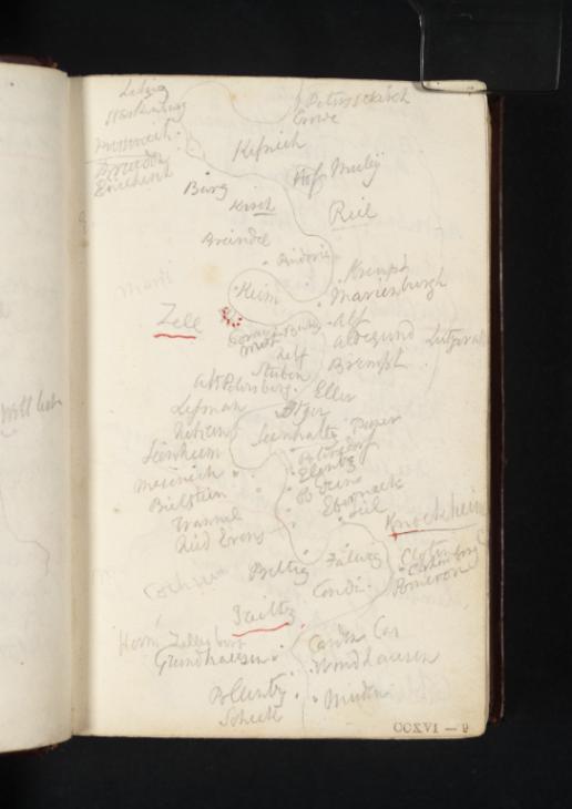
Joseph Mallord William Turner Sketch Map of the Moselle between the Starkenburg and Müden 1824
Image 1 of 2
Joseph Mallord William Turner,
Sketch Map of the Moselle between the Starkenburg and Müden
1824
Joseph Mallord William Turner 1775–1851
Folio 9 Recto:
Sketch Map of the Moselle between the Starkenburg and Müden 1824
D19568
Turner Bequest CCXVI 9
Turner Bequest CCXVI 9
Pencil and pen and red ink on white wove paper, 118 x 78 mm
Inscribed in pencil and pen and red ink by Turner (see main catalogue entry)
Inscribed in blue ink by Ruskin ‘9’ top right
Stamped in black ‘CCXVI–9’ bottom right
Inscribed in pencil and pen and red ink by Turner (see main catalogue entry)
Inscribed in blue ink by Ruskin ‘9’ top right
Stamped in black ‘CCXVI–9’ bottom right
Accepted by the nation as part of the Turner Bequest 1856
References
1909
A.J. Finberg, A Complete Inventory of the Drawings of the Turner Bequest, London 1909, vol.II, p.669, as ‘Sketch map of Moselle, between Müden and Cröff’.
1978
Agnes von der Borch, Studien zu Joseph Mallord William Turners Rheinreisen (1817–1844) (Ph.D thesis, Rheinischen Friedrich-Wilhelms-Universität, Bonn 1972), Bonn 1978, pp.61–2.
1991
Cecilia Powell, Turner’s Rivers of Europe: The Rhine, Meuse and Mosel, exhibition catalogue, Tate Gallery, London 1991, pp.37 note 1 [p.60], 122 no.36.
1995
Cecilia Powell, Turner in Germany, exhibition catalogue, Tate Gallery, London 1995, pp.30 note 4 [p.77], 30–1 fig 17.
1995
Cecilia Powell and Pia Müller-Tamm, William Turner in Deutschland, exhibition catalogue, [Städtische] Kunsthalle Mannheim 1995, p.38 fig.17.
1997
Inge Herold, Turner on Tour, Munich and New York 1997, pp.66–7 (reproduced as ‘CCXVI 5r’).
2001
Andrew Wilton, Inge Bodesohn-Vogel and Helena Robinson, William Turner: Licht und Farbe, exhibition catalogue, Museum Folkwang, Essen 2001, p.36 reproduced.
2003
Barry Venning, Turner, Art & Ideas, London 2003, p.178.
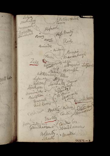
Here Turner has produced a sketch map of the Moselle, beginning at the outskirts of Traben-Trarbach and ending at Müden. The map is a continuation of that on the opposite folio (Tate D19567; Turner Bequest CCXVI 8a). The locations that this cataloguer has been able to transcribe are listed below, with an approximation of the real place names noted in brackets to the right of the transcription where necessary or possible. In this map, Turner has underlined Zell in red ink and indicated that the town is fortified by drawing a dotted semicircle in red ink adjacent to the river.1 Treis is also underlined.
From ‘Litzig’, an old district of Traben-Trarbach, the towns and villages listed on the map include:
‘Starkenburg’
‘Peterskirch’ (Peterskirche, Traben)
‘<’
‘<’
‘Rö[...]erl’
‘Kipnich’
‘Hof Mu[...]y’ (‘Hof’ is the German for ‘farm’ or ‘court’)
‘Burg’
‘Kirch’
‘Reil’
‘Breindel’ (Breidel)
‘Pindoric’ (Pünderich)
‘Kempt’ (Kaimt)
‘Marienburgh’ (Marienburg Convent, Kaimt)
‘Keim’ (possibly also Kaimt)
‘Zell’
‘Coray’ (Corray)
‘Merl’ | ‘B[...]y’ (possibly Bullay)
‘Alf’
‘Aldegund’ (Sankt Aldegund)
‘Lutzerath’
‘Neff’ (Neef)
‘Brempt’ (Bremm)
‘Stuben’ (Kloster Stuben, Bremm)
‘Eller’
‘Alt Petersberg’ (‘Old’ Petersberg, i.e. Petersberg Kapelle, Neef)
‘Le[...]’ (possibly the Lehmerbach, a rivulet)
‘Nehren’
‘Seenhaltz’ (Senhals)
‘Seenheim’ (Senheim)
‘Mesenich’
‘Brielstein’ (possibly Breidern)
‘Polersdorf’ (Poltersdorf)
‘Elentz’ (Ellenz)
‘Frankel’ (Fankel)
‘Ebermach’ (possibly the Ebernacher Bach, a rivulet)
‘Seil’ (possibly Sehl)
‘Knockheim’ (see below)
‘Beltig’ (Bruttig)
‘Cochem’ (Cochem)
‘Falwig’ (Valwig)
‘Cloten’ | ‘Clotenburg’ (Klotten and Klottenburg)
‘Pomeron’ (Pommern)
‘?Tritz’ (Treis)
‘Herm Zillesburg’ (Hermitage of Zillesberg; see Tate D19564; Turner Bequest CCXVI 7)
‘Carden Cas’ (Karden and its castle, Burg Eltz)
‘G[...]ndhausen’
‘W[...]dhausen’
‘Pol[...]tz’
‘Müden’
‘Schuk’
‘Peterskirch’ (Peterskirche, Traben)
‘<
‘<
‘Rö[...]erl’
‘Kipnich’
‘Hof Mu[...]y’ (‘Hof’ is the German for ‘farm’ or ‘court’)
‘Burg’
‘Kirch’
‘Reil’
‘Breindel’ (Breidel)
‘Pindoric’ (Pünderich)
‘Kempt’ (Kaimt)
‘Marienburgh’ (Marienburg Convent, Kaimt)
‘Keim’ (possibly also Kaimt)
‘Zell’
‘Coray’ (Corray)
‘Merl’ | ‘B[...]y’ (possibly Bullay)
‘Alf’
‘Aldegund’ (Sankt Aldegund)
‘Lutzerath’
‘Neff’ (Neef)
‘Brempt’ (Bremm)
‘Stuben’ (Kloster Stuben, Bremm)
‘Eller’
‘Alt Petersberg’ (‘Old’ Petersberg, i.e. Petersberg Kapelle, Neef)
‘Le[...]’ (possibly the Lehmerbach, a rivulet)
‘Nehren’
‘Seenhaltz’ (Senhals)
‘Seenheim’ (Senheim)
‘Mesenich’
‘Brielstein’ (possibly Breidern)
‘Polersdorf’ (Poltersdorf)
‘Elentz’ (Ellenz)
‘Frankel’ (Fankel)
‘Ebermach’ (possibly the Ebernacher Bach, a rivulet)
‘Seil’ (possibly Sehl)
‘Knockheim’ (see below)
‘Beltig’ (Bruttig)
‘Cochem’ (Cochem)
‘Falwig’ (Valwig)
‘Cloten’ | ‘Clotenburg’ (Klotten and Klottenburg)
‘Pomeron’ (Pommern)
‘?Tritz’ (Treis)
‘Herm Zillesburg’ (Hermitage of Zillesberg; see Tate D19564; Turner Bequest CCXVI 7)
‘Carden Cas’ (Karden and its castle, Burg Eltz)
‘G[...]ndhausen’
‘W[...]dhausen’
‘Pol[...]tz’
‘Müden’
‘Schuk’
Turner’s inscription of ‘Knockheim’, underlined partially in red ink, is most likely a reference to a note in Alois Schreiber’s guidebook, where the author writes that the Moselle town Cochem was ‘formerly called Kochenheim’.2
Alice Rylance-Watson
February 2014
How to cite
Alice Rylance-Watson, ‘Sketch Map of the Moselle between the Starkenburg and Müden 1824 by Joseph Mallord William Turner’, catalogue entry, February 2014, in David Blayney Brown (ed.), J.M.W. Turner: Sketchbooks, Drawings and Watercolours, Tate Research Publication, April 2015, https://www


