Joseph Mallord William Turner Views of Boulogne and the Harbour from the North; Studies of the Nearby Coast and Shipping under Sail 1825
Image 1 of 2
-
 Joseph Mallord William Turner, Views of Boulogne and the Harbour from the North; Studies of the Nearby Coast and Shipping under Sail 1825
 -
 Joseph Mallord William Turner, Views of Boulogne and the Harbour from the North; Studies of the Nearby Coast and Shipping under Sail 1825 (Enhanced image)Enhanced image
Joseph Mallord William Turner,
Views of Boulogne and the Harbour from the North; Studies of the Nearby Coast and Shipping under Sail
1825
Joseph Mallord William Turner 1775–1851
Folio 9 Recto:
Views of Boulogne and the Harbour from the North; Studies of the Nearby Coast and Shipping under Sail 1825
D19417
Turner Bequest CCXV 9
Turner Bequest CCXV 9
Pencil on white wove paper, 113 x 189 mm
Inscribed by Turner in pencil ‘Fort Bol’ towards bottom right, ‘1’ and ‘2’ below right of centre, and ‘[?Figure goin] to Market’ below centre, all descending vertically
Inscribed by John Ruskin in blue ink ‘9’ top right, and ‘277’ bottom right
Stamped in black ‘CCXV – 9’ bottom right
Inscribed by Turner in pencil ‘Fort Bol’ towards bottom right, ‘1’ and ‘2’ below right of centre, and ‘[?Figure goin] to Market’ below centre, all descending vertically
Inscribed by John Ruskin in blue ink ‘9’ top right, and ‘277’ bottom right
Stamped in black ‘CCXV – 9’ bottom right
Accepted by the nation as part of the Turner Bequest 1856
References
1909
A.J. Finberg, A Complete Inventory of the Drawings of the Turner Bequest, London 1909, vol.II, p.662, CCXV 9, as ‘Views over hills, with shipping, &c. – “Fort Bol,” “– from the Market.”’.
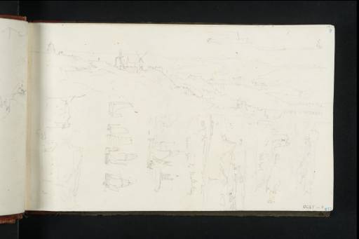
The page was used both horizontally and vertically for views around Boulogne and the adjacent Channel coast. In the largest sketch, across the top half, the prospect is southwards from above the cliffs north of the harbour, with the Belfry (the Beffroi) in the elevated old town on the left, the spire of St Nicholas’s Church aligned beyond the two windmills towards the foreground, and the main harbour channel at the mouth of the River Liane below to the right, with the semi-circular Bassin Napoléon running off it. Above to the right is what seems to be a continuation from the foreground, with cliffs above the harbour and the western pier, then ending at the lost telegraph tower seen on folio 8 verso opposite (D19416). The harbour was developed further in the nineteenth century before being severely damaged in 1944, but the basic layout is still evident, albeit also extended westwards be means of reclaimed land and longer piers.
Subsequent expansion makes the exact viewpoint difficult to establish, although comparable prospects can be obtained from the Calvaire des Marins monument and adjacent open ground off the Rue de la Tour d’Odre (commemorating a lost Roman lighthouse). With the page turned vertically, at the outer corner there is a reprise or variant, with nearby scenes aligned below, framed by pencil lines, running inwards along the lower half relative to the largest drawing. Next comes a small building overlooking the sea, labelled ‘Fort Bol’, and then a two-part view to the north along the coast in the direction of Cap Gris-Nez, and inland north-east to the Napoleonic Colonne de la Grande Armée, with a note of someone likely ‘goin[g] to Market’. The column is seen from south of the harbour on folios 16 recto and 18 recto (D19427, D19431).
Below again, and apparently from much lower down, is a study of sailing boats off the telegraph tower, followed by a typically deft band of studies of boats and ships under sail. Lastly, towards the gutter there is a hilly scene with houses in the foreground. For other views in and around Boulogne in this sketchbook and elsewhere, see under D19416. Compare also loose pencil and watercolour studies, complete with windmills, in the 1845 Boulogne sketchbook (Tate D35421, D35425; Turner Bequest CCCLVIII 17, 19).
Verso:
Blank
Matthew Imms
September 2020
How to cite
Matthew Imms, ‘Views of Boulogne and the Harbour from the North; Studies of the Nearby Coast and Shipping under Sail 1825 by Joseph Mallord William Turner’, catalogue entry, September 2020, in David Blayney Brown (ed.), J.M.W. Turner: Sketchbooks, Drawings and Watercolours, Tate Research Publication, March 2023, https://www

