Joseph Mallord William Turner Inscriptions by Turner: Travel Notes and Figures; River Views Including Arnhem from the Nederrijn; ?Part of a Map or Town Plan with a Bridge 1833
Image 1 of 2
-
 Joseph Mallord William Turner, Inscriptions by Turner: Travel Notes and Figures; River Views Including Arnhem from the Nederrijn; ?Part of a Map or Town Plan with a Bridge 1833 (Inside front cover of sketchbook)Inside front cover of sketchbook
 -
 Joseph Mallord William Turner, Inscriptions by Turner: Travel Notes and Figures; River Views Including Arnhem from the Nederrijn; ?Part of a Map or Town Plan with a Bridge 1833 (Enhanced image)Enhanced image
Inside front cover of sketchbook
Joseph Mallord William Turner,
Inscriptions by Turner: Travel Notes and Figures; River Views Including Arnhem from the Nederrijn; ?Part of a Map or Town Plan with a Bridge
1833
(Inside front cover of sketchbook)
Joseph Mallord William Turner 1775–1851
Inside Front Cover:
Inscriptions by Turner: Travel Notes and Figures; River Views Including Arnhem from the Nederrijn; ?Part of a Map or Town Plan with a Bridge 1833
D32541
Turner Bequest CCCXXII 1
Turner Bequest CCCXXII 1
Pencil on white laid paper, 105 x 170 mm
Inscribed by Turner in pencil ‘5 [overwriting or overwritten with ‘7’ and partly obscured by stamped number] from [?Arnh...] to Col [‘F’ inserted above] 20 in 5 [?only]’ along top, ‘Arnheim’ top centre, ‘[?Sun]’ top right, ‘Gold’ above centre, ‘Bridge’ below left of centre, upside down, ‘[...]’ bottom left (obscured by stamped number), and columns of figures bottom centre, upside down (see main catalogue entry)
Stamped in black ‘CCCXXII’ top left
Stamped in black ‘CCCXXII – 1’ bottom left
Accepted by the nation as part of the Turner Bequest 1856
References
1909
A.J. Finberg, A Complete Inventory of the Drawings of the Turner Bequest, London 1909, vol.II, p.1035, CCCXXII 1, as ‘View of “Arnheim”; also “5” (altered to “7,” or vice versa) “from ... Col. 20 F in 5, &c.,” also various numbers’.
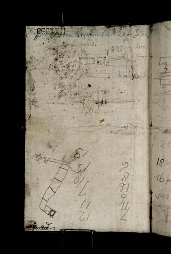
At the top of the page is a fairly faint and swiftly executed view of buildings, representing the city of Arnhem, in the east of the Netherlands, judging from Turner’s inscription, in the German form with a penultimate letter ‘i’. The separate skyline at the top right appears to show the spires of the basilica of St Walburgis and the tower of St Eusebius’s to its west (both now restored after severe damage in 1944). This alignment would indicate a viewpoint on the Nederrijn, looking east-south-eastwards upriver, with what is likely the word ‘Sun’ beside them indicating an early morning scene.
As set out in its Introduction, this sketchbook covers Turner’s homeward route from Augsburg to Rotterdam (see under folios 1 verso and 14 recto respectively; D32543, D32568; CCCXXII 2a, 15). He travelled back down the familiar River Rhine through Germany, working in somewhat randomly from both ends, and, after entering the Netherlands, continued north-west along its Nederrijn distributary to Arnhem, the first identified Dutch subject; Rotterdam lies about sixty miles to its west. There are related views on folio 1 recto opposite (D32542; CCCXXII 2), one being dated ‘2 Oct’, and another on folios 11 verso–12 recto (D32563–D32564; CCCXXII 12a–13), where the low sun and its reflection are shown. Turner also drew the city from a distance in the Arnheim, &c. sketchbook, perhaps of 1844 (Tate D32709–D32780; Turner Bequest CCCXXIV 1a–2).
Across the middle are two views of low wooded riverbanks, perhaps made in the same area, with the second seemingly continuing right across the opposite page, towards a distant church tower. The first, affected like the Arnhem view above by the mottled staining in this half of the page, appears to show the mast of a sailing boat reflected in the water, with the small disk of the rising sun; Turner noted the ‘Gold’ of its reflection in turn. The labelled Arnhem view opposite includes written notes of sunlight breaking through fog.
The pencil notes at the top of the page, typical of the ad hoc travel notes at the ends of Turner’s touring sketchbooks (see also D32542 opposite and folio 62 verso; D32662; CCCXXII 63a), are only partially legible. They possibly refer to a route between Arnhem and Cologne (see under folio 37 recto; D32612; CCCXXII 38), although the first place name is only suggested by its proximity with the clearer rendering below, and could equally well begin with ‘M’, for example; the reading ‘Col’ is less speculative, since the same word appears among the slightly clearer travel notes on the opposite page. There are other notes on D32542 opposite and folio 62 verso (D32662; CCCXXII 63a), opposite the back cover.
The other way up at the bottom of the page is a two-column list of figures, likely financial:
7 12
11 11
6 7
16 10
8 15
6 13
11 11
6 7
16 10
8 15
6 13
To their left is a rough diagram which may be part of a map or town plan, the only clue being the word ‘Bridge’ beside two parallel lines at one end. The pencil marks or brief notes at the corner are partly obscured by the stamped Turner Bequest number. As set out in the Introduction, the foliation of this sketchbook is unusual in that this paste-down is stamped as page ‘1’, with the first free page (D32542 opposite) thus being stamped ‘2’, and so on.
Technical notes:
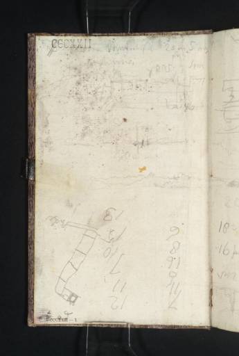
The upper part of this paste-down is marked with extensive mottled staining, probably associated with the dark striations of the mauve paste-paper cover, and perhaps partly affected by the underlying glue. There is also a dark smudge at the bottom left corner, likely also associated with the striations.
Finberg recorded the sketchbook’s ‘leather loops for pencil’.1 One such is anchored here under the centre of the fore-edge, staining it and the first few leaves within the page block. There are two similar stains towards the corners inside the back cover (D32663; CCCXXII 64), as would be expected had the book had the common arrangement of three loops in all, enabling a pencil to be threated through to keep it closed, although no further vestiges of loops remain.
Matthew Imms and Quirine van der Meer Mohr
November 2019
How to cite
Matthew Imms and Quirine van der Meer Mohr, ‘Inscriptions by Turner: Travel Notes and Figures; River Views Including Arnhem from the Nederrijn; ?Part of a Map or Town Plan with a Bridge 1833 by Joseph Mallord William Turner’, catalogue entry, November 2019, in David Blayney Brown (ed.), J.M.W. Turner: Sketchbooks, Drawings and Watercolours, Tate Research Publication, March 2023, https://www

