Joseph Mallord William Turner Studies of Warships under Sail; Coastal Profiles from the English Channel, with Dymchurch, Folkestone, Dover and the South Foreland 1825
Image 1 of 2
-
 Joseph Mallord William Turner, Studies of Warships under Sail; Coastal Profiles from the English Channel, with Dymchurch, Folkestone, Dover and the South Foreland 1825
 -
 Joseph Mallord William Turner, Studies of Warships under Sail; Coastal Profiles from the English Channel, with Dymchurch, Folkestone, Dover and the South Foreland 1825 (Enhanced image)Enhanced image
Joseph Mallord William Turner,
Studies of Warships under Sail; Coastal Profiles from the English Channel, with Dymchurch, Folkestone, Dover and the South Foreland
1825
Joseph Mallord William Turner 1775–1851
Folio 5 Verso:
Studies of Warships under Sail; Coastal Profiles from the English Channel, with Dymchurch, Folkestone, Dover and the South Foreland 1825
D19410
Turner Bequest CCXV 5a
Turner Bequest CCXV 5a
Pencil on white wove paper, 189 x 113 mm
Inscribed by Turner in pencil ‘Blu Sea’ towards top right, ‘[?Dim]’, ‘Hythe’ and ‘Folkstone’ above centre, ‘Dover’ centre right, and ‘St M[...]’ and ‘South Foreland’ below left of centre, and ‘R[...]’ below right of centre, over coastal profiles
Inscribed by Turner in pencil ‘Blu Sea’ towards top right, ‘[?Dim]’, ‘Hythe’ and ‘Folkstone’ above centre, ‘Dover’ centre right, and ‘St M[...]’ and ‘South Foreland’ below left of centre, and ‘R[...]’ below right of centre, over coastal profiles
Accepted by the nation as part of the Turner Bequest 1856
References
1909
A.J. Finberg, A Complete Inventory of the Drawings of the Turner Bequest, London 1909, vol.II, p.662, CCXV 5a, as ‘Views from Channel. – “Hythe, Folkestone, Dover, South Foreland,” &c.’.
Finberg later annotated his 1909 Inventory entry (‘Views from Channel. – “Hythe, Folkestone, Dover, South Foreland,” &c.’): ‘Perhaps this is on the return journey’.1 For the possible relationship between the views around Dover in this sketchbook and the autumn 1825 Continental subjects taking up the rest of it, see under folio 1 recto (D19401).
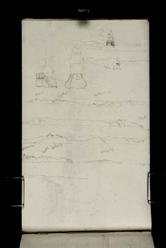
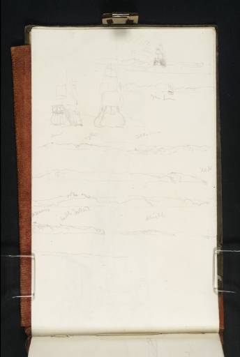
With the page turned vertically, there are eight bands of sketches running down from the top (outer) edge. Framed by pencil lines at the top right is a thumbnail view of a large sailing ship seen from astern, with cliffs in the distance below a cloudy or rainy sky. Below is a variant with a note of ‘Blu[e] Sea’ and to its left, two studies of broad-beamed ships (or perhaps the same twice) under sail, again seen from the rear with cliffs beyond; they are likely warships, like those on folio 1 verso (D19402).
Five coastal profiles follow. The first, probably labelled ‘Dim’ for Dymchurch, ‘Hythe’ and ‘Folk[e]stone’, ranges about ten miles along the Kent coast, apparently seen from east of Folkestone, towards Dover (about seven miles further east again). The second looks along the stretch east of Folkestone, with slight indications of ‘Dover’ Castle on the right. Thirdly, the castle is now on the left, with cliffs undulating towards the South Foreland about two and a half miles to the east-north-east. The left-hand half of the fourth strip shows the ‘South Foreland’ with what seems to be a note of St Margaret’s at Cliffe, the village just to its north-east, although the note of ‘St M[...]’ comes first. The less clearly defined profile to the right is also labelled, with a word or two beginning with ‘R’, and the final sketch, although still carefully outlined, lacks obvious landmarks. The sequence suggesting a voyage from west to east around the south side of Kent, working down the page.
Matthew Imms
September 2020
How to cite
Matthew Imms, ‘Studies of Warships under Sail; Coastal Profiles from the English Channel, with Dymchurch, Folkestone, Dover and the South Foreland 1825 by Joseph Mallord William Turner’, catalogue entry, September 2020, in David Blayney Brown (ed.), J.M.W. Turner: Sketchbooks, Drawings and Watercolours, Tate Research Publication, March 2023, https://www

